- 製品 製品ロケーションサービス
ジオフェンスからカスタム ルート検索まで、ロケーションに関する複雑な課題を解決します
プラットフォームロケーションを中心としたソリューションの構築、データ交換、可視化を実現するクラウド環境
トラッキングとポジショニング屋内または屋外での人やデバイスの高速かつ正確なトラッキングとポジショニング
API および SDK使いやすく、拡張性が高く、柔軟性に優れたツールで迅速に作業を開始できます
開発者エコシステムお気に入りの開発者プラットフォーム エコシステムでロケーションサービスにアクセスできます
- ドキュメント ドキュメント概要 概要サービス サービスアプリケーション アプリケーションSDKおよび開発ツール SDKおよび開発ツールコンテンツ コンテンツHERE Studio HERE StudioHERE Workspace HERE WorkspaceHERE Marketplace HERE Marketplaceプラットフォーム基盤とポリシーに関するドキュメントプラットフォーム基盤とポリシーに関するドキュメント
- 価格
- リソース リソースチュートリアル チュートリアル例 例ブログとリリースの公開 ブログとリリースの公開変更履歴 変更履歴開発者向けニュースレター 開発者向けニュースレターナレッジベース ナレッジベースフィーチャー 一覧フィーチャー 一覧サポートプラン サポートプランシステムステータス システムステータスロケーションサービスのカバレッジ情報ロケーションサービスのカバレッジ情報学習向けのサンプルマップデータ学習向けのサンプルマップデータ
- ヘルプ
GeoJSON データソースを更新します
生成されたコードには、 GeoJsonDataSource アップロードされたファイルのデータを視覚化するのインスタンスがあります。 カスタム GeoJSON オブジェクトを表示するように変更してみましょう。 これを行うに index.ts は、以下の説明に従ってファイルを開き、変更します。
まず、ファイルのインポートセクションに、FeatureCollectionおよびMapViewEventNamesのこのインポートを追加します。
import { FeatureCollection } from "@here/olp-geojson-datasource";
import { MapViewEventNames } from "@here/harp-mapview";
次に、次のコードを index.ts ファイルのcreateGeoJsonDataSource関数の末尾、return geoJsonDataSource;の行の直前に追加し ます。
const geoJsonData: FeatureCollection = {
    "type": "FeatureCollection",
    "features":
        [{
            "type": "Feature",
            "geometry":
                {
                    "type": "Polygon",
                    "coordinates": [
                        [
                            [13.304, 52.499],
                            [13.350, 52.458],
                            [13.430, 52.468],
                            [13.441, 52.521],
                            [13.371, 52.537],
                            [13.304, 52.499]
                        ]
                    ]
                },
            "properties": {},
        }]
};

if (dataInspector.mapView !== undefined) {
    dataInspector.mapView.addEventListener(MapViewEventNames.DataSourceConnect, event => {
        if (geoJsonDataSource !== undefined && event.dataSourceName === geoJsonDataSource.name) {
            geoJsonDataSource.renderGeoJson(geoJsonData); // visualize the GeoJSON object
        }
    });
}
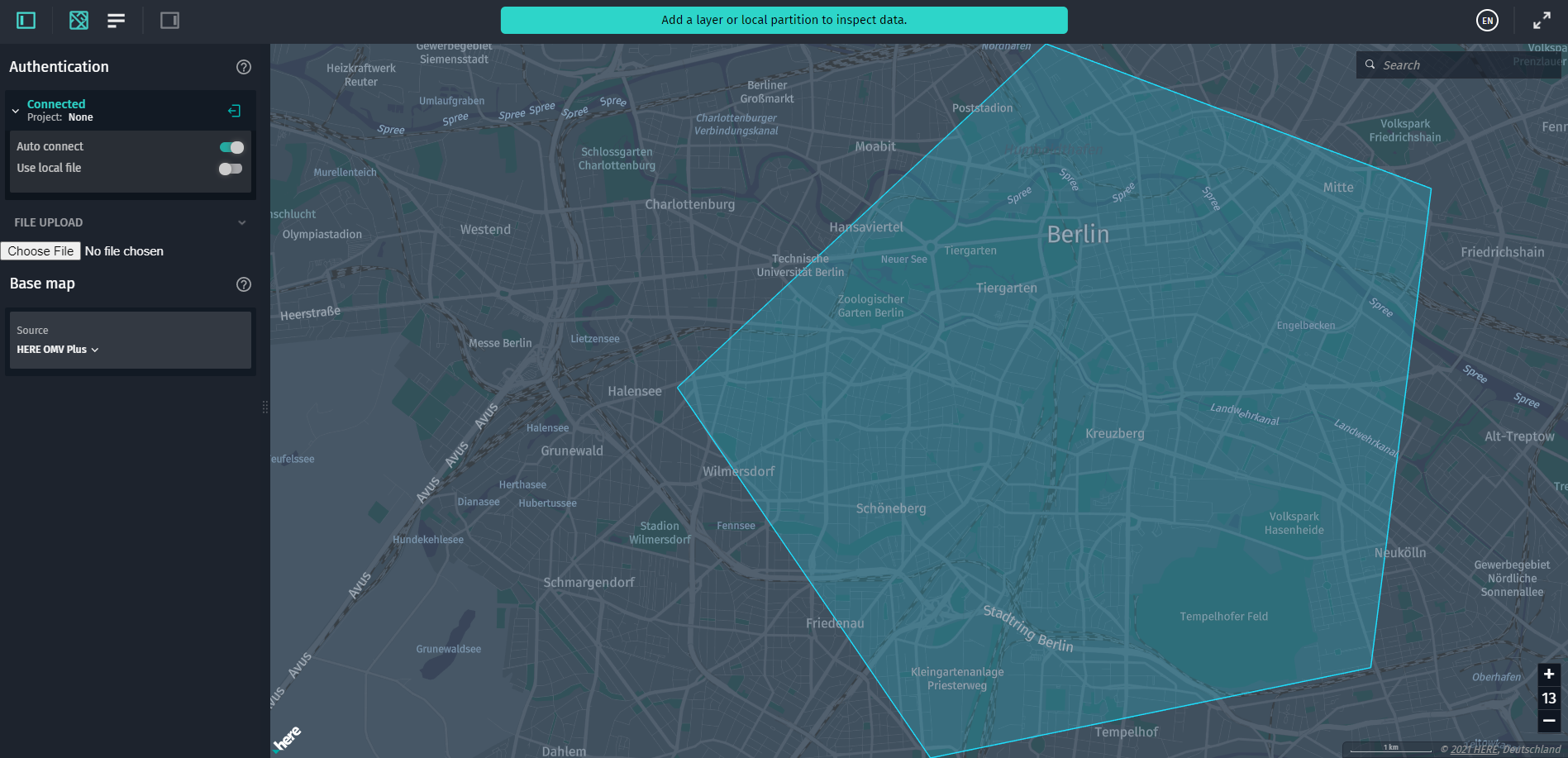
ページを更新すると、ベルリンの中央エリアをカバーするペンタゴンの図形がマップに描画されます。