- 製品 製品ロケーションサービス
ジオフェンスからカスタム ルート検索まで、ロケーションに関する複雑な課題を解決します
プラットフォームロケーションを中心としたソリューションの構築、データ交換、可視化を実現するクラウド環境
トラッキングとポジショニング屋内または屋外での人やデバイスの高速かつ正確なトラッキングとポジショニング
API および SDK使いやすく、拡張性が高く、柔軟性に優れたツールで迅速に作業を開始できます
開発者エコシステムお気に入りの開発者プラットフォーム エコシステムでロケーションサービスにアクセスできます
- ドキュメント ドキュメント概要 概要サービス サービスアプリケーション アプリケーションSDKおよび開発ツール SDKおよび開発ツールコンテンツ コンテンツHERE Studio HERE StudioHERE Workspace HERE WorkspaceHERE Marketplace HERE Marketplaceプラットフォーム基盤とポリシーに関するドキュメントプラットフォーム基盤とポリシーに関するドキュメント
- 価格
- リソース リソースチュートリアル チュートリアル例 例ブログとリリースの公開 ブログとリリースの公開変更履歴 変更履歴開発者向けニュースレター 開発者向けニュースレターナレッジベース ナレッジベースフィーチャー 一覧フィーチャー 一覧サポートプラン サポートプランシステムステータス システムステータスロケーションサービスのカバレッジ情報ロケーションサービスのカバレッジ情報学習向けのサンプルマップデータ学習向けのサンプルマップデータ
- ヘルプ
ドラッグ可能な方向を有効にします
経由地 を追加してマーカーをドラッグすることで、ユーザーが既定のルーティングを操作できるようにすることで、ナビゲーションの効率と精度を改善できます。
たとえば、地図上のドラッグ可能な道順案内は、倉庫業のロジスティクス管理者にとって貴重なツールになります。 特定の配達トラックのニーズに基づいてルートをカスタマイズすることで、配達を効率的かつタイムリーに行うことができます。
さらに、地図上でマーカーをドラッグすることで、特定の道路や通過したいエリアを含むようにルートをカスタマイズできます。 このレベルのパーソナライゼーションにより、ユーザーは自分の好みやニーズに合わせてカスタマイズされたルートを作成できます。
このチュートリアルでは、 Maps API for JavaScript を使用して地図上の原点と目的地のマーカーをプロットし、それらのマーカー間の最速ルートを計算して表示する方法を示します。 このチュートリアルでは、ユーザーが経由地 マーカーを追加または削除した場合、または既存のマーカーの位置を変更した場合に、デフォルトルートを動的に再計算する方法について説明します。
- 作業を開始する前に
- ベース マップ を作成します
- 地図上に原点と目的地をプロットします
- 出発地点と目的地の間の最速ルートを計算します
- マーカーをドラッグ可能にします
- 経由地 を追加または削除します
- ソースコード
- 次のステップ
作業を開始する前に
マップをレンダリングする JavaScript コードのコンテナとして、基本的な HTML ページを作成します。
-
HTML ファイル内で
<head>、次の例に示すように、要素が必要なライブラリ コンポーネントを参照していることを確認します。<script type="text/javascript" src="https://js.api.here.com/v3/3.1/mapsjs-core.js"></script> <script type="text/javascript" src="https://js.api.here.com/v3/3.1/mapsjs-service.js"></script> <script type="text/javascript" src="https://js.api.here.com/v3/3.1/mapsjs-mapevents.js"></script> <script type="text/javascript" charset="utf-8" src="https://js.api.here.com/v3/3.1/mapsjs-ui.js" ></script> <link rel="stylesheet" type="text/css" href="https://js.api.here.com/v3/3.1/mapsjs-ui.css" /> -
HTML ページに CSS スタイルを追加します。 たとえば、次の基本的なスタイルを使用して、マップビューポイント を囲むコンテナの高さと幅の 100% に設定できます。
body {width: 100%; height: 100%; position: absolute; margin: 0px; padding: 0px; overflow: hidden;}
#map {position:absolute; top:0; bottom:0; width:100%; height: 100%;}
ベース マップ を作成します
作成した HTML コンテナに、 Maps API for JavaScript を使用してマップを表示し、マップの対話を有効にする JavaScript コードを追加します。
-
<script>作成した HTML ファイルの要素内で、次のコード スニペット を貼り付けるか、参照します。// Initiate and authenticate your connection to the HERE platform: const platform = new H.service.Platform({ 'apikey': 'Your API key' }); // Obtain the default map types from the platform object: const defaultLayers = platform.createDefaultLayers(); // Instantiate (and display) a map: var map = new H.Map( document.getElementById("map"), // Center the map on Great Britain with the zoom level of 6: defaultLayers.vector.normal.map, { zoom: 6, center: { lat: 53.480759, lng: -2.242631 } }); // MapEvents enables the event system. // The behavior variable implements default interactions for pan/zoom (also on mobile touch environments). const behavior = new H.mapevents.Behavior(new H.mapevents.MapEvents(map)); // Enable dynamic resizing of the map, based on the current size of the enclosing cntainer window.addEventListener('resize', () => map.getViewPort().resize()); // Create the default UI: var ui = H.ui.UI.createDefault(map, defaultLayers, ); -
コード スニペット で
apikey、変数の値を独自の API キー に置き換えます。
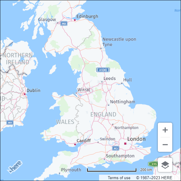
結果: 結果の HTML ファイルでは、次 6の例に示すように、イギリスを中心としたベース マップ がのズーム レベル でレンダリングされます。
地図上に原点と目的地をプロットします
地図で、原点と目的地を表すマーカーを追加します。
-
getMarkerIcon()カスタム SVG スタイルを各マーカーに適用する関数を作成します。/** * Returns an instance of H.map.Icon to style the markers * @param {number|string} id An identifier that will be displayed as marker label * * @return {H.map.Icon} */ function getMarkerIcon(id) { const svgCircle = `<svg width="30" height="30" version="1.1" xmlns="http://www.w3.org/2000/svg"> <g id="marker"> <circle cx="15" cy="15" r="10" fill="#0099D8" stroke="#0099D8" stroke-width="4" /> <text x="50%" y="50%" text-anchor="middle" fill="#FFFFFF" font-family="Arial, sans-serif" font-size="12px" dy=".3em">${id}</text> </g></svg>`; return new H.map.Icon(svgCircle, { anchor: { x: 10, y: 10 } }); }スタイルによって、マーカー ID に対応するテキストが中央にある青い円のマーカーが作成されます。
-
addMarker()マップにオブジェクトマーカーを追加し、カスタム SVG スタイルを適用する関数を作成します。/** * Create an instance of H.map.Marker and add it to the map * * @param {object} position An object with 'lat' and 'lng' properties defining the position of the marker * @param {string|number} id An identifier that will be displayed as marker label * @return {H.map.Marker} The instance of the marker that was created */ function addMarker(position, id) { const marker = new H.map.Marker(position, { data: { id }, icon: getMarkerIcon(id), }); map.addObject(marker); return marker; } -
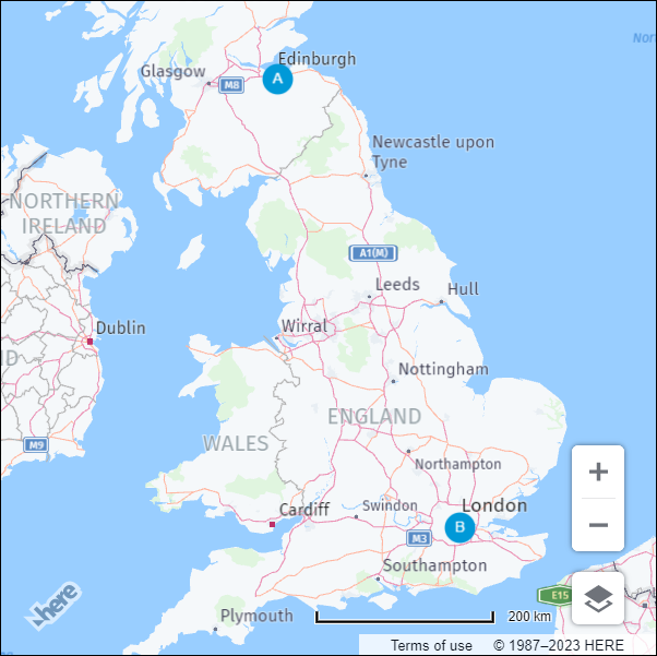
次の例に示すように、原点マーカーと目的地マーカーの座標を定義します。
const origin = { lat: 55.953251, lng: -3.188267 }; // Edinburgh const destination = { lat: 51.507797, lng: -0.128604 }; // London -
addMarker()この関数を呼び出して、異なる ID を使用して、指定した場所の地図上に原点マーカーと目的地マーカーをプロットします。const originMarker = addMarker(origin, 'A'); const destinationMarker = addMarker(destination, 'B');
結果: 次の図に示すように、地図には原点と目的地の座標の静的マーカーが表示されます。
マーカーの詳細について は、「マーカーオブジェクト」を参照してください。
出発地点と目的地の間の最速ルートを計算します
HERE Routing API V8 を使用して、デザイン地点と目的地地点の間の最速ルートを決定します。
-
ルーティングパラメータを指定します。
const routingParams = { 'origin': `${origin.lat},${origin.lng}`, 'destination': `${destination.lat},${destination.lng}`, 'transportMode': 'car', 'return': 'polyline' };ここで、
-
originルートの出発地点の緯度 と経度 を表す文字列です。 -
destinationルートの宛先の緯度 および経度 を表す文字列です。 -
transpotModeルートに使用する輸送手段を指定する文字列です。 この例では、に設定carされています。これは、ルートが車での移動に最適化されることを意味します。 -
returnAPI からの応答の形式を示す文字列です。この例では、に設定polylineされています。これは、応答がポリライン としてルートを表す文字列であることを意味します。
-
-
H.service.RoutingService8オブジェクトを初期化 :const router = platform.getRoutingService(null, 8); -
マップ上の計算ルートを表すポリライン を保持するために、空の変数を初期化します。
let routePolyline; -
H.service.RoutingService8オブジェクトのcalculateRouteメソッドのコールバック 関数として使用するrouteResponseHandler()関数を定義します。/** * Handler for the H.service.RoutingService8#calculateRoute call * * @param {object} response The response object returned by calculateRoute method */ function routeResponseHandler(response) { const sections = response.routes[0].sections; const lineStrings = []; sections.forEach((section) => { // convert Flexible Polyline encoded string to geometry lineStrings.push(H.geo.LineString.fromFlexiblePolyline(section.polyline)); }); const multiLineString = new H.geo.MultiLineString(lineStrings); const bounds = multiLineString.getBoundingBox(); // Create the polyline for the route if (routePolyline) { // If the routePolyline we just set the new geometry routePolyline.setGeometry(multiLineString); } else { // routePolyline is not yet defined, instantiate a new H.map.Polyline routePolyline = new H.map.Polyline(multiLineString, { style: { lineWidth: 5 } }); } // Add the polyline to the map map.addObject(routePolyline); } -
updateRoute定義済みのパラメータを使用してルーティングサービスを呼び出す機能を定義します。function updateRoute() { router.calculateRoute(routingParams, routeResponseHandler, console.error); }calculateRouteメソッドは、で指定されたパラメータに基づいroutingParamsて、 2 つ以上のポイント間の最速ルートを決定します。 ルートが計算されるとrouteResponseHandler()、応答オブジェクトをパラメータとして使用して関数が呼び出されます。 -
updateRoute 関数を呼び出して、起点と終点の間のルートを表示します。
updateRoute();
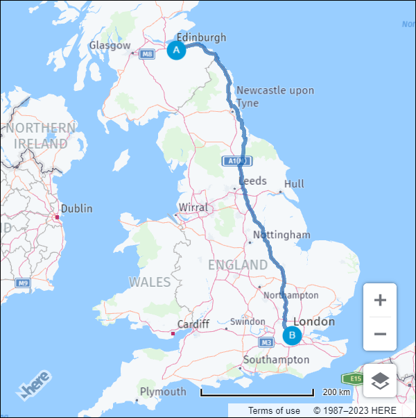
結果: 次の図に示すように、エジンバラからロンドン への最速ルートが車で表示されます。
ルーティングの詳細について は、 HERE Routing API V8 を参照してください。
マーカーをドラッグ可能にします
ユーザーが、対応するマーカーを新しい位置にドラッグして、最初の原点と目的地を編集できるようにします。 マーカーの位置が変更されたときにルートを動的に再計算するようにマップを設定できます。
-
addMarker機能内で、マーカーオブジェクトのドラッグを有効にします。marker変数で 、H.map.Markerオブジェクトのvolatile設定オプションを true に設定して、スムーズなドラッグを有効にします。-
marker.draggableプロパティをに設定trueします。更新された関数定義のリファレンスを参照してください。
function addMarker(position, id) { const marker = new H.map.Marker(position, { data: { id }, icon: getMarkerIcon(id), // Enable smooth dragging volatility: true }); // Enable draggable markers marker.draggable = true; map.addObject(marker); return marker; }
-
dragstartイベントのマップイベントリスナーを追加します。/** * Listen to the dragstart and store the relevant position information of the marker */ map.addEventListener('dragstart', function(ev) { const target = ev.target; const pointer = ev.currentPointer; if (target instanceof H.map.Marker) { // Disable the default draggability of the underlying map behavior.disable(H.mapevents.Behavior.Feature.PANNING); var targetPosition = map.geoToScreen(target.getGeometry()); // Calculate the offset between mouse and target's position // when starting to drag a marker object target['offset'] = new H.math.Point( pointer.viewportX - targetPosition.x, pointer.viewportY - targetPosition.y); } }, false);このイベントは、ユーザーが地図上でマーカーのドラッグを開始したときにトリガーされます。 このイベントリスナーの関数は、イベントのターゲットがマーカーオブジェクトであるかどうかを確認します。 true の場合、この関数は、基本となるマップの既定のドラッグ可否を無効にし、マーカーオブジェクトのドラッグを開始したときに、マウスとターゲットの位置の間のオフセット を計算します。 オフセット を使用して、地図上でドラッグされたマーカーの新しい位置が計算されます。
-
dragイベントのマップイベントリスナーを追加します。/** * Listen to the drag event and move the position of the marker as necessary */ map.addEventListener('drag', function(ev) { const target = ev.target; const pointer = ev.currentPointer; if (target instanceof H.map.Marker) { target.setGeometry( map.screenToGeo(pointer.viewportX - target['offset'].x, pointer.viewportY - target['offset'].y) ); } }, false);このイベントリスナーの関数は、ポインターの現在の位置に基づいてマーカーがドラッグされると、マップ上のマーカーの位置を更新します。
-
dragendイベントのマップイベントリスナーを追加します。/** * Listen to the dragend and update the route */ map.addEventListener('dragend', function(ev) { const target = ev.target; if (target instanceof H.map.Marker) { // re-enable the default draggability of the underlying map // when dragging has completed behavior.enable(H.mapevents.Behavior.Feature.PANNING); const coords = target.getGeometry(); const markerId = target.getData().id; // Update the routing params `origin` and `destination` properties // in case we dragging either the origin or the destination marker if (markerId === 'A') { routingParams.origin = `${coords.lat},${coords.lng}`; } else if (markerId === 'B') { routingParams.destination = `${coords.lat},${coords.lng}`; } updateRoute(); } }, false);dragendイベントはupdateRoute、更新されたマーカー座標に基づいて、新しいルートを動的に再計算して表示するように関数をトリガーするように定義されます。
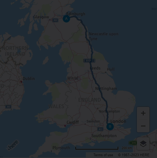
結果: 次の図に示すように、原点マーカーと目的地マーカーを新しい場所に移動し、地図が最速ルートを動的に再計算できるようになりました。

経由地 を追加または削除します
ユーザーがドラッグ可能な経由地 マーカーを追加または削除できるようにすることで、マップの対話性をさらに向上できます。 この機能により、ルート計画の柔軟性と効率性が向上します。
-
ルート経由地 に対応するマーカーの空の配列を初期化します。
// This array holds instances of H.map.Marker representing the route waypoints const waypoints = [] -
次 の例に示すように、ルーティングロジックで
routingParams変数を更新して新しいviaパラメータを追加します。const routingParams = { 'origin': `${origin.lat},${origin.lng}`, 'destination': `${destination.lat},${destination.lng}`, // defines multiple waypoints 'via': new H.service.Url.MultiValueQueryParameter(waypoints), 'transportMode': 'car', 'return': 'polyline' };は
MultiValueQueryParameter、原点と終点の間に複数の経由地 の座標を保持する文字列パラメーターを作成します。 この文字列が HERE Routing API クエリに追加されます。 -
updateRoute()次の例に示すように、経由地 を含めるように機能を調整します。function updateRoute() { // Add waypoints the route must pass through routingParams.via = new H.service.Url.MultiValueQueryParameter( waypoints.map(wp => `${wp.getGeometry().lat},${wp.getGeometry().lng}`)); router.calculateRoute(routingParams, routeResponseHandler, console.error); }viaこのパラメータでは、オリジンと宛先の間でルートが通過する必要がある追加の経由地 が追加されます。 -
tapイベントのマップイベントリスナーを追加します。/** * Listen to the tap event to add a new waypoint */ map.addEventListener('tap', function(ev) { const target = ev.target; const pointer = ev.currentPointer; const coords = map.screenToGeo(pointer.viewportX, pointer.viewportY); if (!(target instanceof H.map.Marker)) { const marker = addMarker(coords, waypoints.length + 1); waypoints.push(marker); updateRoute(); } });このイベントハンドラでは、目的の場所にある地図をクリックして新しい経由地 をマーカーとして追加できます。これにより、ルートが更新されます。
-
dbltapイベントのマップイベントリスナーを追加します。/** * Listen to the dbltap event to remove a waypoint */ map.addEventListener('dbltap', function(ev) { const target = ev.target; if (target instanceof H.map.Marker) { // Prevent the origin or destination markers from being removed if (['origin', 'destination'].indexOf(target.getData().id) !== -1) { return; } const markerIdx = waypoints.indexOf(target); if (markerIdx !== -1) { // Remove the marker from the array of way points waypoints.splice(markerIdx, 1) // Iterate over the remaining waypoints and update their data waypoints.forEach((marker, idx) => { const id = idx + 1; // Update marker's id marker.setData({ id }); // Update marker's icon to show its new id marker.setIcon(getMarkerIcon(id)) }); } // Remove the marker from the map map.removeObject(target); updateRoute(); } });このイベントリスナーの関数は、ユーザーがマーカーをダブルタップしたときに経由地 の削除を処理します。
ユーザーがマーカーをダブルタップすると、まずマーカーが原点マーカーまたは宛先マーカーかどうかを確認します。 マーカーが削除されている場合、この機能ではマーカーを削除できません。 それ以外の場合
waypointsは、配列内のマーカーのインデックスが検索され、配列からマーカーが削除されます。waypoints配列からマーカーを削除すると、配列内の残りのマーカーのデータとアイコンが更新waypointsされ、新しい順序が反映されます。 最後updateRoute()に、この関数はマップからマーカーを削除し、この関数を呼び出して、新しい経由地 のセットに基づいてルートを更新します。詳細について は、「複数の経由地を使用したルート」経由地 を参照してください。
-
マーカーをダブルタップしたときにマップのズームを無効にするマップビヘイビアーを追加します。
behavior.disable(H.mapevents.Behavior.Feature.DBL_TAP_ZOOM);
結果: 次の例に示すように、経由地 マーカーを新しい場所に追加、削除、またはドラッグできるようになりました。また、マップは各イベントの後で最速のレートを動的に再計算します。
ソースコード
次のセクションでは、このチュートリアルで使用したすべてのソースコードについて説明します。
注
次のコードを試す前 apikey に、パラメーターの値をご自身の API キー に置き換えてください。
//BOILERPLATE CODE TO INITIALIZE THE MAP
const platform = new H.service.Platform({
'apikey': 'Your API Key'
});
// Obtain the default map types from the platform object:
const defaultLayers = platform.createDefaultLayers();
// Instantiate (and display) a map:
var map = new H.Map(
document.getElementById("map"),
defaultLayers.vector.normal.map, {
zoom: 6,
center: {
lat: 53.480759,
lng: -2.242631
}
});
// MapEvents enables the event system
// Behavior implements default interactions for pan/zoom (also on mobile touch environments)
const behavior = new H.mapevents.Behavior(new H.mapevents.MapEvents(map));
// Disable zoom on double-tap to allow removing waypoints on double-tap
behavior.disable(H.mapevents.Behavior.Feature.DBL_TAP_ZOOM);
window.addEventListener('resize', () => map.getViewPort().resize());
// Create the default UI:
var ui = H.ui.UI.createDefault(map, defaultLayers, );
// ROUTING LOGIC STARTS HERE
// This variable holds the instance of the route polyline
let routePolyline;
/**
* Handler for the H.service.RoutingService8#calculateRoute call
*
* @param {object} response The response object returned by calculateRoute method
*/
function routeResponseHandler(response) {
const sections = response.routes[0].sections;
const lineStrings = [];
sections.forEach((section) => {
// convert Flexible Polyline encoded string to geometry
lineStrings.push(H.geo.LineString.fromFlexiblePolyline(section.polyline));
});
const multiLineString = new H.geo.MultiLineString(lineStrings);
const bounds = multiLineString.getBoundingBox();
// Create the polyline for the route
if (routePolyline) {
// If the routePolyline we just set has the new geometry
routePolyline.setGeometry(multiLineString);
} else {
// If routePolyline is not yet defined, instantiate a new H.map.Polyline
routePolyline = new H.map.Polyline(multiLineString, {
style: {
lineWidth: 5
}
});
}
// Add the polyline to the map
map.addObject(routePolyline);
}
 /**
  * Returns an instance of H.map.Icon to style the markers
  * @param {number|string} id An identifier that will be displayed as marker label
  *
  * @return {H.map.Icon}
  */
 function getMarkerIcon(id) {
     const svgCircle = `<svg width="30" height="30" version="1.1" xmlns="http://www.w3.org/2000/svg">
                           <g id="marker">
                             <circle cx="15" cy="15" r="10" fill="#0099D8" stroke="#0099D8" stroke-width="4" />
                             <text x="50%" y="50%" text-anchor="middle" fill="#FFFFFF" font-family="Arial, sans-serif" font-size="12px" dy=".3em">${id}</text>
                           </g></svg>`;
     return new H.map.Icon(svgCircle, {
         anchor: {
             x: 10,
             y: 10
         }
     });
 }
/**
* Create an instance of H.map.Marker and add it to the map
*
* @param {object} position An object with 'lat' and 'lng' properties defining the position of the marker
* @param {string|number} id An identifier that will be displayed as marker label
* @return {H.map.Marker} The instance of the marker that was created
*/
function addMarker(position, id) {
const marker = new H.map.Marker(position, {
data: {
id
},
icon: getMarkerIcon(id),
// Enable smooth dragging
volatility: true
});
// Enable draggable markers
marker.draggable = true;
map.addObject(marker);
return marker;
}
/**
* This method calls the routing service to retrieve the route line geometry
*/
function updateRoute() {
routingParams.via = new H.service.Url.MultiValueQueryParameter(
waypoints.map(wp => `${wp.getGeometry().lat},${wp.getGeometry().lng}`));
// Call the routing service with the defined parameters
router.calculateRoute(routingParams, routeResponseHandler, console.error);
}
// ADD MARKERS FOR ORIGIN/DESTINATION
 const origin = {
     lat: 55.953251,
     lng: -3.188267
 }; // Edinburgh
 const destination = {
     lat: 51.507797,
     lng: -0.128604
 }; // London
 const originMarker = addMarker(origin, 'A');
 const destinationMarker = addMarker(destination, 'B');
// CALCULATE THE ROUTE BETWEEN THE TWO WAYPOINTS
// This array holds instances of H.map.Marker representing the route waypoints
const waypoints = []
// Define the routing service parameters
const routingParams = {
'origin': `${origin.lat},${origin.lng}`,
'destination': `${destination.lat},${destination.lng}`,
// defines multiple waypoints
'via': new H.service.Url.MultiValueQueryParameter(waypoints),
'transportMode': 'car',
'return': 'polyline'
};
// Get an instance of the H.service.RoutingService8 service
const router = platform.getRoutingService(null, 8);
// Call the routing service with the defined parameters and display the route
updateRoute();
/**
* Listen to the dragstart and store relevant position information of the marker
*/
map.addEventListener('dragstart', function(ev) {
const target = ev.target;
const pointer = ev.currentPointer;
if (target instanceof H.map.Marker) {
// Disable the default draggability of the underlying map
behavior.disable(H.mapevents.Behavior.Feature.PANNING);
var targetPosition = map.geoToScreen(target.getGeometry());
// Calculate the offset between mouse and target's position
// when starting to drag a marker object
target['offset'] = new H.math.Point(
pointer.viewportX - targetPosition.x, pointer.viewportY - targetPosition.y);
}
}, false);
/**
* Listen to the dragend and update the route
*/
map.addEventListener('dragend', function(ev) {
const target = ev.target;
if (target instanceof H.map.Marker) {
// re-enable the default draggability of the underlying map
// when dragging has completed
behavior.enable(H.mapevents.Behavior.Feature.PANNING);
const coords = target.getGeometry();
const markerId = target.getData().id;
// Update the routing params `origin` and `destination` properties
// in case we dragging either the origin or the destination marker
if (markerId === 'A') {
routingParams.origin = `${coords.lat},${coords.lng}`;
} else if (markerId === 'B') {
routingParams.destination = `${coords.lat},${coords.lng}`;
}
updateRoute();
}
}, false);
 /**
  * Listen to the drag event and move the position of the marker as necessary
  */
 map.addEventListener('drag', function(ev) {
     const target = ev.target;
     const pointer = ev.currentPointer;
     if (target instanceof H.map.Marker) {
         target.setGeometry(
             map.screenToGeo(pointer.viewportX - target['offset'].x, pointer.viewportY - target['offset'].y)
         );
     }
 }, false);
 /**
  * Listen to the tap event to add a new waypoint
  */
 map.addEventListener('tap', function(ev) {
     const target = ev.target;
     const pointer = ev.currentPointer;
     const coords = map.screenToGeo(pointer.viewportX, pointer.viewportY);

     if (!(target instanceof H.map.Marker)) {
         const marker = addMarker(coords, waypoints.length + 1);
         waypoints.push(marker);
         updateRoute();
     }
 });
/**
* Listen to the dbltap event to remove a waypoint
*/
map.addEventListener('dbltap', function(ev) {
const target = ev.target;
if (target instanceof H.map.Marker) {
// Prevent origin or destination markers from being removed
if (['origin', 'destination'].indexOf(target.getData().id) !== -1) {
return;
}
const markerIdx = waypoints.indexOf(target);
if (markerIdx !== -1) {
// Remove the marker from the array of way points
waypoints.splice(markerIdx, 1)
// Iterate over the remaining waypoints and update their data
waypoints.forEach((marker, idx) => {
const id = idx + 1;
// Update marker's id
marker.setData({
id
});
// Update marker's icon to show its new id
marker.setIcon(getMarkerIcon(id))
});
}
// Remove the marker from the map
map.removeObject(target);
updateRoute();
}
});
次のステップ
- 他の Maps API for JavaScript の使用例については 、例を参照してください。
- Maps API for JavaScript の設計と機能については 、『 API リファレンス』を参照してください。