- 製品 製品ロケーションサービス
ジオフェンスからカスタム ルート検索まで、ロケーションに関する複雑な課題を解決します
プラットフォームロケーションを中心としたソリューションの構築、データ交換、可視化を実現するクラウド環境
トラッキングとポジショニング屋内または屋外での人やデバイスの高速かつ正確なトラッキングとポジショニング
API および SDK使いやすく、拡張性が高く、柔軟性に優れたツールで迅速に作業を開始できます
開発者エコシステムお気に入りの開発者プラットフォーム エコシステムでロケーションサービスにアクセスできます
- ドキュメント ドキュメント概要 概要サービス サービスアプリケーション アプリケーションSDKおよび開発ツール SDKおよび開発ツールコンテンツ コンテンツHERE Studio HERE StudioHERE Workspace HERE WorkspaceHERE Marketplace HERE Marketplaceプラットフォーム基盤とポリシーに関するドキュメントプラットフォーム基盤とポリシーに関するドキュメント
- 価格
- リソース リソースチュートリアル チュートリアル例 例ブログとリリースの公開 ブログとリリースの公開変更履歴 変更履歴開発者向けニュースレター 開発者向けニュースレターナレッジベース ナレッジベースフィーチャー 一覧フィーチャー 一覧サポートプラン サポートプランシステムステータス システムステータスロケーションサービスのカバレッジ情報ロケーションサービスのカバレッジ情報学習向けのサンプルマップデータ学習向けのサンプルマップデータ
- ヘルプ
日本のデータを使用したはじめに
このセクションでは、日本固有のデータおよびマップスタイルで HERE Maps API for Javascript を使用する方法について説明します。 このデータへのアクセス権は、ユーザーの契約によって決まります。 このレイヤーへのアクセス権を取得するに は、営業担当者に連絡するか、または弊社にお問い合わせください。
ユースケース
以下のセクションで は、「クイックスタート 」の章の手順について説明しますが、さらに次の方法についても説明します。
"core"タイル API が Vector JavaScript API のレイヤーを呼び出すように設定します- 日本のデータに適したマップスタイルを取得します。
- 日本国内のルートを表示します。
API コードライブラリを読み込みます
JavaScript API のページへの掲載方法に変更は <head> ありません。 HERE は、コアおよびサービスモジュールをロードし、モバイルデバイスで最適なパフォーマンスを確保する完全な要素です。
<!DOCTYPE html>
  <html>
    <head>
      ...
      <meta name="viewport" content="initial-scale=1.0,
        width=device-width" />
      <script src="https://js.api.here.com/v3/3.1/mapsjs-core.js"
        type="text/javascript" charset="utf-8"></script>
      <script src="https://js.api.here.com/v3/3.1/mapsjs-service.js"
        type="text/javascript" charset="utf-8"></script>
      ...
    </head>
    <body>
      <div style="width: 640px; height: 480px" id="mapContainer"></div>
バックエンドサービスとの通信を初期化します
Platform API キー を渡して、通常どおりオブジェクトを初期化します。
var platform = new H.service.Platform({
  'apikey': '{YOUR_API_KEY}'
});
地図を初期化します
- 日本のデータを提供する
coreエンドポイントを使用するように事前に設定されている Vector タイルサービスオブジェクトのインスタンスを作成します。 - 日本のデータの表示に最適化されたマップスタイルを使用するレイヤーを作成します。 スタイルは 、地図カスタマイズツールを使用して調整できます。
H.Map以下を指定して、オブジェクトをインスタンス化します。- マップのコンテナ要素
- 前のステップで作成したレイヤー
- 地図を表示するズーム レベル
- 地図を中央に配置するポイントの地理座標
// configure an OMV service to use the `core` enpoint
var omvService = platform.getOMVService({path:  'v2/vectortiles/core/mc'});
var baseUrl = 'https://js.api.here.com/v3/3.1/styles/omv/oslo/japan/';

// create a Japan specific style
var style = new H.map.Style(`${baseUrl}normal.day.yaml`, baseUrl);

// instantiate provider and layer for the basemap
var omvProvider = new H.service.omv.Provider(omvService, style);
var omvlayer = new H.map.layer.TileLayer(omvProvider, {max: 22});

// instantiate (and display) a map:
var map = new H.Map(
    document.getElementById('mapContainer'),
    omvlayer,
    {
      zoom: 17,
      center: {lat: 35.68026, lng: 139.76744}
    });
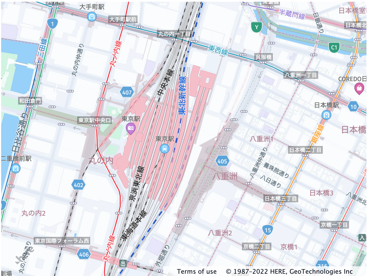
実装では、次のマップイメージが表示されます。
ジオ コーディングとルーティング
ジオ コーディング and Search and Routing API V8 を日本で使用するために、データを追加調整する必要はありません。
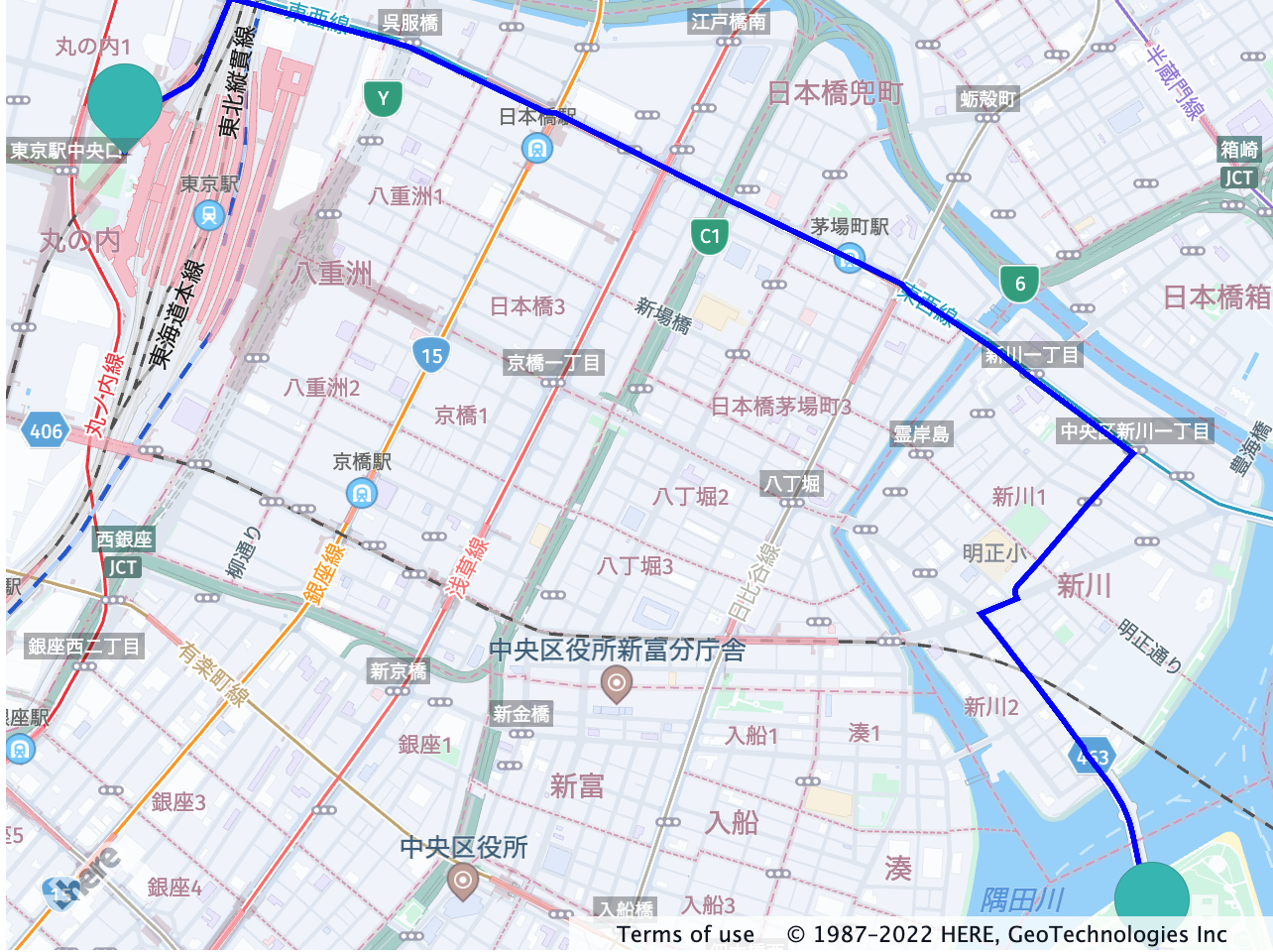
次の例では、東京エリアの 2 つのポイントをジオコードして、それらのポイント間のルートを計算する方法を示します。 以下のスニペット:
- ルートの始点と終点をジオコード化します。
- 応答を解析してルートポリラインを表示するルーティングパラメータおよびルーティングコールバックを定義します。
- ルーティングサービスをインスタンス化し、ルートを計算します
let origin;
let destination;

let onError = (error) => {
  alert(error.message);
}

// create an instance of the routing service and make a request
let router = platform.getRoutingService(null, 8);

// Define a callback function to process the routing response:
let onResult = function(result) {
  // ensure that at least one route was found
  if (result.routes.length) {
    result.routes[0].sections.forEach((section) => {
         // Create a linestring to use as a point source for the route line
        let linestring = H.geo.LineString.fromFlexiblePolyline(section.polyline);

        // Create a polyline to display the route:
        let routeLine = new H.map.Polyline(linestring, {
          style: { strokeColor: 'blue', lineWidth: 3 }
        });

        // Create a marker for the start point:
        let startMarker = new H.map.Marker(section.departure.place.location);

        // Create a marker for the end point:
        let endMarker = new H.map.Marker(section.arrival.place.location);

        // Add the route polyline and the two markers to the map:
        map.addObjects([routeLine, startMarker, endMarker]);

        // Set the map's viewport to make the whole route visible:
        map.getViewModel().setLookAtData({bounds: routeLine.getBoundingBox()});
    });
  }
};

let routingParameters = {
  'transportMode': 'car',
  // Include the route shape in the response
  'return': 'polyline'
};

// Define a callback that calculates the route
let calculateRoute = () => {
  // Make sure that both destination and origin are present
  if (!origin || !destination) return;

  // Add origin and destination to the routing parameters
  routingParameters.origin = origin;
  routingParameters.destination = destination;

  router.calculateRoute(routingParameters, onResult, onError);
}

// get the instance of the Search service
var service = platform.getSearchService();

// geocode origin point
service.geocode({
  q: '東京都中央区佃1‐11‐8'
}, (result) => {
  origin = result.items[0].position.lat + ',' + result.items[0].position.lng;
  calculateRoute();
}, onError);

// geocode a destination point
service.geocode({
  q: '東京都千代田区丸の内1‐9'
}, (result) => {
  destination = result.items[0].position.lat + ',' + result.items[0].position.lng;
  calculateRoute();
}, onError)
次の図は、上記のコードからのルーティングリクエストの結果を示しています。