- Products ProductsLocation Services
Solve complex location problems from geofencing to custom routing
PlatformCloud environments for location-centric solution development, data exchange and visualization
Tracking & PositioningFast and accurate tracking and positioning of people and devices, indoors or outdoors
APIs & SDKsEasy to use, scaleable and flexible tools to get going quickly
Developer EcosystemsAccess Location Services on your favorite developer platform ecosystem
- Documentation DocumentationOverview OverviewServices ServicesApplications ApplicationsDevelopment Enablers Development EnablersContent ContentHERE Studio HERE StudioHERE Workspace HERE WorkspaceHERE Marketplace HERE MarketplacePlatform Foundation and Policy Documents Platform Foundation and Policy Documents
- Pricing
- Resources ResourcesTutorials TutorialsExamples ExamplesBlog & Release Announcements Blog & Release AnnouncementsChangelog ChangelogDeveloper Newsletter Developer NewsletterKnowledge Base Knowledge BaseFeature List Feature ListSupport Plans Support PlansSystem Status System StatusLocation Services Coverage Information Location Services Coverage InformationSample Map Data for Students Sample Map Data for Students
- Help
Fleet Telematics Advanced Data Sets
Showing Fleet Telematics Advanced Data Sets Layer on the Map
HERE Maps API for JavaScript provides an easy way to overlay Fleet Telematics Advanced Data Sets thematic layers on the map. The Fleet Telematics Advanced Data Sets layers can be used to enrich the map experience by providing additional data: postcodes, census data, road classes, junction views etc. More information about available thematic layers is provided by the layers Fleet Telematics Advanced Data Sets REST API endpoint.
The code example below shows a simple use case involving the Fleet Telematics Advanced Data Sets thematic layer in which the map user can tap on the postcode data polygon centroid markers to view more information. When executed, the code performs the following operations:
- Gets an instance of the Platform Data Extension service.
- Creates Fleet Telematics Advanced Data Sets provider with the
'PSTLCB_GEN'thematic layer, and polyline rendering types.
/**
 * Assuming that "map" and "platform" are already initialized
 */
 // Create default map layers:
var service = platform.getPlatformDataService();

style = new H.map.SpatialStyle();
// create tile provider and layer that displays postcode boundaries
var boundariesProvider = new H.service.extension.platformData.TileProvider(service,
{
  layer: 'PSTLCB_GEN', level: 12
}, {
  resultType: H.service.extension.platformData.TileProvider.ResultType.POLYLINE,
  styleCallback: function(data) {return style}
});
var boundaries = new H.map.layer.TileLayer(boundariesProvider);
map.addLayer(boundaries);
The example above uses H.map.SpatialStyle with the default settings, however, the API allows changing the style callback to take custom data attributes into account. The code below extends the initial steps from the previous examples by:
- Creating additional layer with
'PSTLCB_MP'thematic layer, that contains postcode area centroids, and setting itsresultTypetoH.map.Marker. - Registering a tap event listener with the tile provider responsible for the
'PSTLCB_MP'layer.
// create tile provider and layer that displays postcode area centroids
var centroidsProvider = new H.service.extension.platformData.TileProvider(service,
{
  layer: 'PSTLCB_MP', level: 12
}, {
  resultType: H.service.extension.platformData.TileProvider.ResultType.MARKER
});
var centroids = new H.map.layer.MarkerTileLayer(centroidsProvider);
map.addLayer(centroids);

// add events listener, that outputs data provided by the Platform Data Extenstion and
// associated with the H.map.Marker
centroidsProvider.addEventListener('tap', function(ev) {
  var markerData = ev.target.getData();
  console.log(markerData.getCell('POSTAL_CODE'), markerData.getCell('ISO_COUNTRY_CODE'))
});
The listener is a callback function to be invoked when the map user taps on a map (spatial) object, for example a marker. It retrieves the object from the event passed to it and outputs information associated with the object to the console.
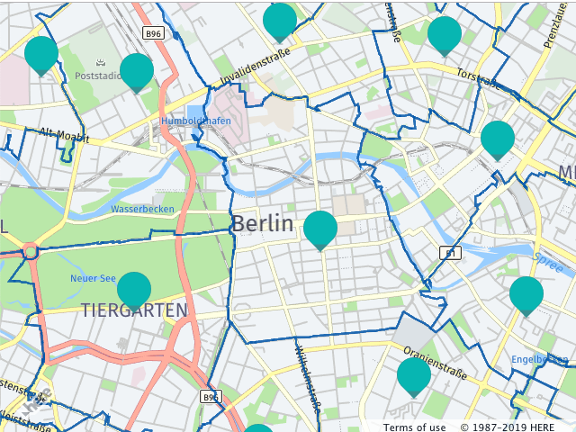
The image below shows the observable effects of this code on the map.
Showing and Matching Fleet Telematics Advanced Data Sets Search Results
Another option to display Fleet Telematics Advanced Data Sets data with HERE Maps API for JavaScript is to use the SearchRequest class. This option should be used when existing data (geocoding, routing etc. results) should be annotated with the data provided by Fleet Telematics Advanced Data Sets REST API thematic layers. The SearchRequest data event enables flexible way to perform search for data within the bounding box and to match the results with existing data by various attributes, such as link ids, names etc.
The code example below shows how to use SearchRequest functionality to existing data with the Fleet Telematics Advanced Data Sets. When executed, the code performs the following operations:
- Creates a
SearchRequestfor the'EVCHARGING_POI'thematic layer. - Adds an event listener to the
'data'event of theSearchRequest. - The event listener processes the data available in the event argument and matches it against the available set of link ids. If there is a match, the code adds a map object to the map.
/**
 * Assuming that "map" and "platform" are already initialized, and there is
 * a processed routing response that includes a polyline and an array of 'linkids'
 * that represent legs of the route.
 */
var service = platform.getPlatformDataService();

// search the charging stations by the bounding box
service.searchByBoundingBox(['EVCHARGING_POI'], ['POI_ID'], polyline.getBoundingBox(),
  (rows) => {
    rows.forEach((row) => {
      map.addObject(
        new H.map.Marker(
          // read marker position from the data row
          row.getCell('WKT').getGeometries()[0]
        )
      );
    })
  }, (e) => {console.log(e)});