- Products ProductsLocation Services
Solve complex location problems from geofencing to custom routing
PlatformCloud environments for location-centric solution development, data exchange and visualization
Tracking & PositioningFast and accurate tracking and positioning of people and devices, indoors or outdoors
APIs & SDKsEasy to use, scaleable and flexible tools to get going quickly
Developer EcosystemsAccess Location Services on your favorite developer platform ecosystem
- Documentation DocumentationOverview OverviewServices ServicesApplications ApplicationsDevelopment Enablers Development EnablersContent ContentHERE Studio HERE StudioHERE Workspace HERE WorkspaceHERE Marketplace HERE MarketplacePlatform Foundation and Policy Documents Platform Foundation and Policy Documents
- Pricing
- Resources ResourcesTutorials TutorialsExamples ExamplesBlog & Release Announcements Blog & Release AnnouncementsChangelog ChangelogDeveloper Newsletter Developer NewsletterKnowledge Base Knowledge BaseFeature List Feature ListSupport Plans Support PlansSystem Status System StatusLocation Services Coverage Information Location Services Coverage InformationSample Map Data for Students Sample Map Data for Students
- Help
Overlays
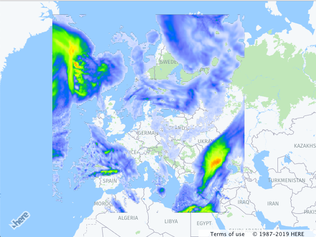
The HERE Maps API for JavaScript provides an easy means of overlaying the region on the map with the bitmap image. The H.map.Overlay object can be used to render static or dynamic data using static images fetched from the server or dynamic procedural bitmap. The overlay object also offers an easy way to animate the data for example a weather information or any other data that can change over time.
Adding an Overlay to the Map
The example below demonstrates how to add an image overlay to the map.
// instantiate a map object:
var map = new H.Map(...);

// create an overlay that will use a weather map as a bitmap
var overlay = new H.map.Overlay(
  new H.geo.Rect(
    70.72849153520343, -24.085683364175395,
    29.569664922291, 44.216452317817016
  ),
  'https://heremaps.github.io/maps-api-for-javascript-examples/image-overlay/data/0.png'
);

// add overlay to the map
map.addObject(overlay);
The code creates a map object (see also Get Started), instantiates an overlay, providing the bounding box of the area that it must cover and an image URL, and, finally, adds the overlay to the map. The image below shows the result.